How to Build a Low-Power Asset & Personnel Tracking System for Mining Sites
Mining sites are among the most hostile environments for any tracking system — and the problem is rarely the tracker itself. It is the environment around it.
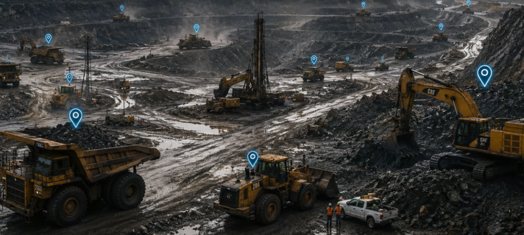
A typical open-pit or underground mine spans several square kilometres, operates 24/7 across rotating shifts, and sits in a remote location where the nearest cellular tower may be tens of kilometres away. Inside that footprint you will find:
- Hundreds of moving assets: haul trucks, loaders, drills and fuel bowsers
- Severe RF conditions: deep pit walls that block line-of-sight, heavy machinery that acts as moving RF shields, dust and rain that attenuate signals, and underground drifts where no satellite or cellular signal reaches at all.
Against this backdrop, the question every mining safety and operations manager asks is simple: “Where is everyone and everything, right now — and can I trust that answer when I need it most?”
Why Traditional GPS + Cellular Tracking Has Limitations in Mining
A cellular-connected GPS tracker does two things: it calculates position from satellites, and it ships that position over a 4G/5G modem. Both steps break down in mining in ways that are expensive to fix.

GNSS alone cannot cover the whole mine
GNSS requires a clear view of the sky. In an open-pit mine, that view narrows as you descend into the pit — high walls block satellites, and position accuracy degrades or drops out entirely near the pit floor and in shaded corners. Underground, GNSS does not work at all. The result is a map with holes: assets and people vanish exactly where visibility matters most for safety.
4G/5G coverage is patchy and expensive to extend
Most remote mines have little or no public cellular coverage. Private LTE/5G networks can be built, but they require a dense grid of towers, fibre or licensed spectrum planning, and ongoing maintenance. For a mine that needs to track a few hundred tags across a wide area, the cost-per-connected-device of a private cellular network is hard to justify — especially when the data being sent is a short location payload every few minutes.
Cellular modems are power-hungry
A 4G modem, even in low-power modes, consumes significantly more energy than a LoRa radio. For a battery-powered personnel badge or a small asset tag, that means either a large, heavy battery or frequent charging and replacement. I
Maintenance overhead in remote locations
Every device that needs frequent charging, SIM management, or firmware updates over cellular is a device that generates site visits. In mining, a site visit means a vehicle, a driver, and lost production time. The total cost of ownership is dominated by operations, not by the upfront hardware price.
The Hybrid Positioning Concept: Use Each Radio for What It Does Best
A robust mining tracking system does not rely on a single wireless technology. It layers three complementary radios, each assigned a specific job:
| Layer | Technology | Job | Why it fits |
| Outdoor Positioning | GNSS | Absolute coordinates in open-sky areas | Free, global, meter-level accuracy where sky is visible |
| Indoor Positioning | Bluetooth Beacons | Relative / zone-level position where GNSS fails | Low cost, low power, works indoors and in RF-shadowed areas |
| Backhaul | LoRaWAN | Long-range, low-power data uplink from tags to platform | Kilometre-scale range, months battery life, no per-device SIM |
| Management | Cloud / on-prem platform | Visualisation, geofencing, alerts, reporting | Where the data becomes decisions |
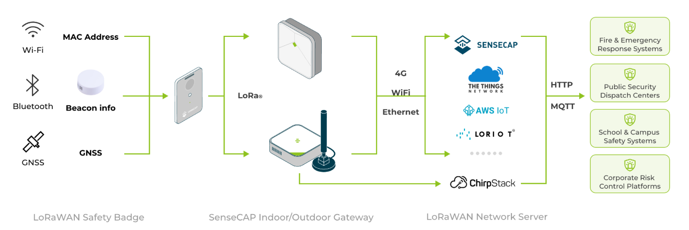
The key insight: the tag does not need to send its position over a high-power cellular modem. It can determine its position and then ship a tiny payload over LoRaWAN.
Open-sky areas: GNSS + LoRaWAN
In the open pit or on haul roads, the tag has a clear view of the sky. It wakes on its configured interval, acquires a GNSS fix, and sends a compact LoRaWAN uplink containing latitude, longitude, battery level, and any sensor data. The LoRaWAN gateway receives the signal from up to several kilometres away and forwards it to the network server. No cellular modem is involved. No SIM. No data plan. The tag’s battery can last for months on a single charge because LoRaWAN uplinks are measured in milliamp-seconds, not the seconds of transmit time a cellular modem requires.
Underground and enclosed spaces: BLE Beacon + LoRaWAN
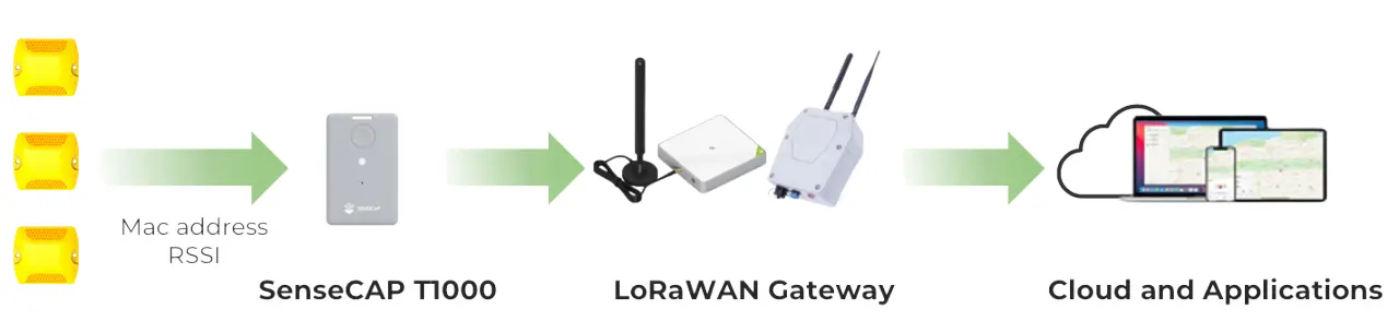
As the miner descends deeper into the pit, walks behind a high wall, or enters a maintenance workshop, GNSS becomes unreliable or unavailable. The tag automatically falls back to BLE: it scans for nearby fixed Bluetooth beacons, reads the MAC addresses and RSSI of the strongest beacons, and sends that list over LoRaWAN. The platform then resolves the tag’s position to a triangulated position within a few metres.
The handoff is seamless to the user
From the platform operator’s perspective, the tag always reports a location. Whether that location came from GNSS coordinates or a beacon ID is a detail the system handles automatically. The operator sees a dot on a map, a name, a timestamp, and a battery indicator.
Hardware Roles: T1000-B, BC02/BC03, and the LoRaWAN Gateway
T1000-B — The Mobile Tracking Device (Asset & Personnel Tag)
The T1000-B White Label Card Tracker is the mobile element of the system. Roughly the size of a credit card (85 × 55 × 6.5 mm) and IP65-rated, it is designed to be worn as a personnel badge or affixed to small assets and tools. What makes it suitable for mining hybrid tracking is that it integrates all three positioning modes in one device.
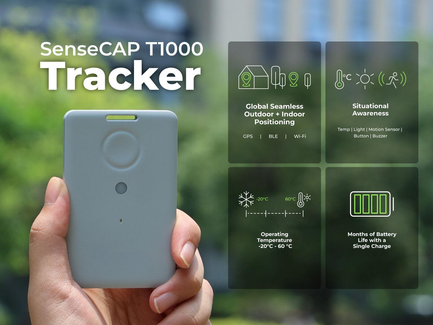
The white-label variant means system integrators and solution providers can brand the device as their own, ship it under their own packaging, and present a unified solution to mining customers without revealing the underlying hardware supplier.
BC02 — The Fixed Outdoor Bluetooth Beacon
The BC02 Outdoor Bluetooth Beacon is the fixed reference point of the system. Its specifications are deliberately tuned for harsh outdoor and industrial deployment:
- IP68ingress protection and IK08 impact resistance — dust-tight, submersible, and resistant to the knocks and bumps common on active mine sites.
- −40 °C to +85 °C operating temperature — covering both high-altitude cold-climate mines and hot desert operations.
- 4000 mAh Li/SOCl₂ primary battery with a rated life of more than 7 years under default configuration
- BLE 5.0, iBeacon protocol, broadcasting at configurable power (−40 to +4 dBm) and interval (100 ms to 5 s), with an open-area range of up to 75 metres.
- Rugged ABS+PC enclosure, 115 × 100 × 29 mm, 169 g, with mounting flanges for screw or strap installation.
BC03 — The Indoor Bluetooth Beacon (for workshops, offices, and enclosed plants)
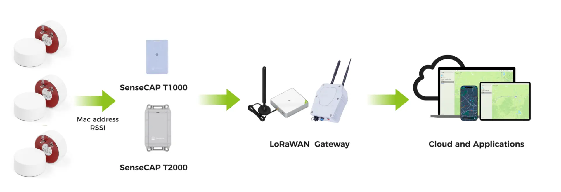
For indoor environments — maintenance workshops, administration buildings, processing plants, and storage warehouses — the BC03 Indoor Bluetooth Beacon provides the same beacon function in a compact, ceiling-mount form factor (Φ50 × 20.5 mm, ~45 g). It uses a 2400 mAh Li/SOCl₂ battery, BLE 5.0, and iBeacon protocol, with recommended installation at 2.5–3 m height and 5–10 m spacing for meter-level accuracy.
LoRaWAN Gateway — The Long-Range Data Backhaul
The gateway is the bridge between the tag’s LoRaWAN radio and the IP network. A single LoRaWAN gateway mounted on an elevated point can cover line-of-sight ranges of several kilometres
Because LoRaWAN uses sub-GHz frequencies with excellent diffraction and penetration, a gateway can often receive signals from tags inside workshops and even shallow underground drifts without additional infrastructure.
Mining Management Platform — Data Visualisation & Management
The platform is where raw location data becomes operational value. A mining-grade tracking platform should provide:
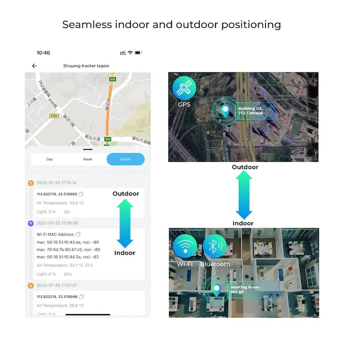
e platform can be cloud-hosted or deployed on-premises, depending on the mine’s data sovereignty and connectivity requirements. The Sensecraft platform involves all these functions.
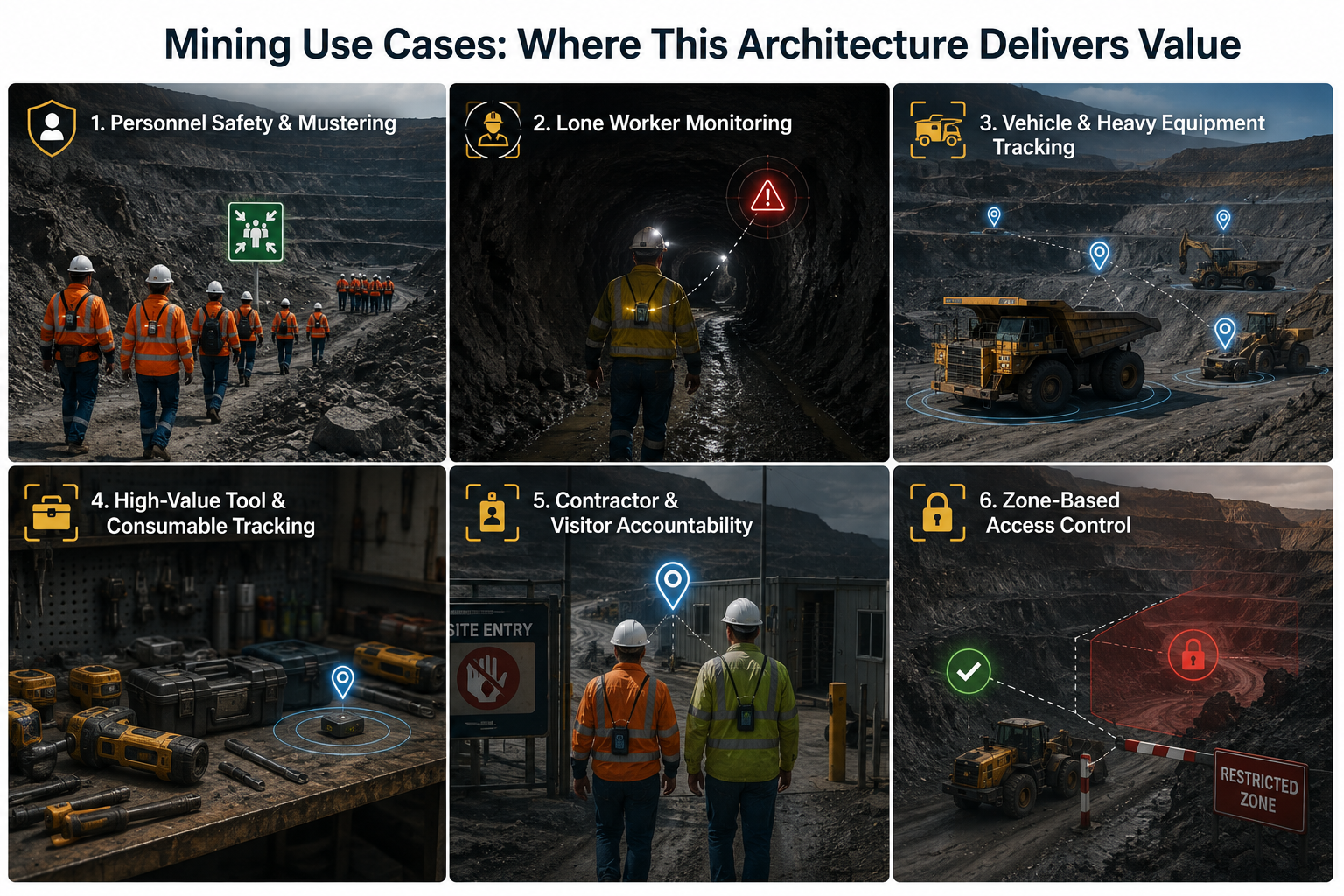
Mining Use Cases: Where This Architecture Delivers Value
- Personnel Safety & Mustering:
- Lone Worker Monitoring
- Vehicle & Heavy Equipment Tracking
- High-Value Tool & Consumable Tracking
- Contractor & Visitor Accountability
- Zone-Based Access Control
Business Benefits: Why This Architecture Wins on Total Cost
- Dramatically lower connectivity cost
- Lower power = smaller batteries = lower device cost
- Lower maintenance burden
- Coverage where cellular cannot reach
- Seamless indoor/outdoor handoff
- Scalability
- Data ownership and integration
The Seeed Solution: Building Blocks for Mining IoT Providers
Ready to scope a tracking deployment for your mine or your mining customer? Explore the T1000-B White Label Tracker and the BC02 Outdoor Bluetooth Beacon, or contact Seeed for bulk pricing and custom integration support. For mining system integrators and IoT solution providers, the value of this architecture is that it is modular and white-label-ready. You are not buying a closed tracking product — you are assembling a solution from interoperable building blocks that you can brand, configure, and integrate as your own.
- Faster time-to-deployment — proven, off-the-shelf hardware that has been deployed in industrial and outdoor environments globally.
- Lower R&D burden: — no need to design and certify your own tracker, beacon, or gateway from scratch.
- White-label flexibility — present the solution as your own, with your branding, your pricing, and your support relationship with the mining customer.
- Global availability — Seeed ships from warehouses in the US, Germany, and China, with regional frequency variants to match the mine’s country.
About Author
