How Does a Radar Rain Gauge Measure Rainfall? From Radar Signals to Validated Rainfall Data
Rainfall measurement may seem straightforward, but different rain gauges can produce different readings even when they are exposed to the same rainfall. The reason lies not only in sensor accuracy, but also in how each measurement technology detects and interprets precipitation.
Why Rainfall Measurement Can Vary?
Different sensing technologies measure precipitation in different ways, and their results can vary depending on rainfall intensity, duration, and environmental conditions.
For example, light or short-duration rainfall can be particularly challenging to capture consistently. A rainfall event may begin with a very low intensity, increase rapidly, and then stop within a short period. Capturing these changes requires not only sufficient measurement resolution, but also a sensing method that can continuously respond to changes in precipitation.
This is also why measurements obtained under controlled laboratory conditions may differ from those collected in real outdoor environments. Laboratory testing allows a sensor to be evaluated under specific and repeatable rainfall conditions, while field deployment introduces additional variables such as wind, temperature, surrounding structures, and changing precipitation patterns.
For radar rainfall measurement, these differences lead to an important technical consideration: how does the system turn a radar signal into a rainfall intensity value in mm/h?
A radar rain gauge does not directly measure a value such as 10 mm/h. Instead, it detects characteristics of precipitation-related radar signals and processes them through a rainfall estimation algorithm to calculate rainfall intensity.
This also gives context to specifications such as 0.01 mm/h resolution. A finer resolution allows the system to represent smaller changes in measured rainfall intensity, but resolution alone does not determine the overall accuracy of a rainfall measurement system.
To understand the reliability of radar rainfall data, we therefore need to look beyond the specification sheet and examine how radar detects precipitation, how the measurement algorithm processes the signal, and how the resulting data performs under controlled testing.
The following sections will walk through this process, from the radar signal itself to rainfall estimation and laboratory validation.
What Does a Radar Rain Gauge Actually Measure?
From Radar Echoes to Rainfall Intensity
Unlike conventional rainfall measurement methods that collect or directly observe water, a radar rain gauge detects precipitation through electromagnetic waves.
The radar sensor continuously transmits electromagnetic waves into the measurement area. When these waves interact with falling raindrops, part of the transmitted energy is scattered back toward the sensor. The characteristics of this returned signal contain information about the precipitation within the radar’s sensing volume.
For Doppler radar, the motion of raindrops also produces a frequency shift in the returned signal. Because the Doppler shift is related to the velocity of the scattering targets, the radar can obtain information about the falling velocity of precipitation particles. Vertically pointing Doppler radar has been widely studied for this purpose, including the relationship between Doppler spectra, raindrop fall velocity, and raindrop size distribution.
However, the radar does not directly measure rainfall intensity in mm/h.
Instead, the measurement can be understood as a multi-step process:
Radar Signal → Echo/Doppler Information → Precipitation Characteristics → Rainfall Algorithm → Rainfall Intensity
This distinction is important because rainfall intensity is determined by more than simply detecting whether raindrops are present.
From Doppler Information to Raindrop Characteristics
A falling raindrop is characterized not only by its presence, but also by factors such as:
- fall velocity
- drop size
- number or concentration of drops
- distribution of different drop sizes
These parameters are closely related to rainfall rate.
In physical terms, rainfall rate represents the volume of water passing through a unit horizontal area per unit time. It therefore depends on both the amount of water contained in the falling drops and their falling velocity. A simplified representation is:
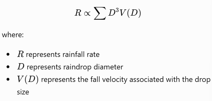
However, actual rainfall retrieval is more complex than this simplified relationship. Natural rainfall contains raindrops with different sizes and velocities, so the system needs to process the measured signal and estimate the overall precipitation characteristics rather than treating every raindrop as identical.
Turning Signal Characteristics into Rainfall Intensity
This is where the rainfall estimation algorithm becomes important.
The radar signal itself is not expressed as a value such as 2.5 mm/h. Instead, the system processes the measured signal characteristics and applies a rainfall estimation model to convert them into a rainfall intensity value.
This means the final measurement is determined by two closely connected components:
Radar sensing → captures precipitation-related information
Rainfall algorithm → interprets that information and estimates rainfall intensity
The algorithm therefore plays an important role in determining how radar observations are translated into the rainfall values reported by the sensor.
This also explains why radar rainfall measurement is not simply a matter of detecting whether rain is present. The system needs to extract meaningful physical information from the radar signal and then convert that information into a quantitative rainfall measurement.
Why the Algorithm Matters
Rainfall is highly variable. Raindrop size, concentration, and falling velocity can change throughout a rainfall event. As a result, the relationship between radar observations and rainfall intensity is not necessarily fixed under all conditions.
Factors such as the raindrop size distribution, precipitation characteristics, and assumptions used in the retrieval model can affect the resulting rainfall estimate.
This is why evaluating a radar rain gauge requires more than confirming that the radar can detect precipitation. The entire measurement chain—from signal detection to rainfall estimation—needs to be validated against a reference measurement.
So, how do we know whether the rainfall value calculated from radar signals is reliable?
How Laboratory Testing Validates Radar Rainfall Measurements?
To evaluate whether the Doppler radar rainfall sensors meet their design requirements, a comparative monitoring test was conducted using multiple radar-based weather sensors and conventional tipping-bucket rain gauges.
The test involved 14 devices in total: five SenseCAP S700-C all-in-one weather stations with integrated radar rainfall sensors, three standalone radar rainfall sensors, and six tipping-bucket rain gauges. All devices were installed at the same test site and positioned at the same elevation to provide comparable observation conditions.
SenseCAP Sensor Hub 4G Data Logger by Seeed Studio was used to collect data from the tested devices. This setup enabled synchronized data collection, allowing rainfall measurements from different sensors to be compared over the same observation period.
The test was designed to assess the rainfall monitoring performance of the radar sensors against the reference measurements and determine whether their results met the product design requirements.
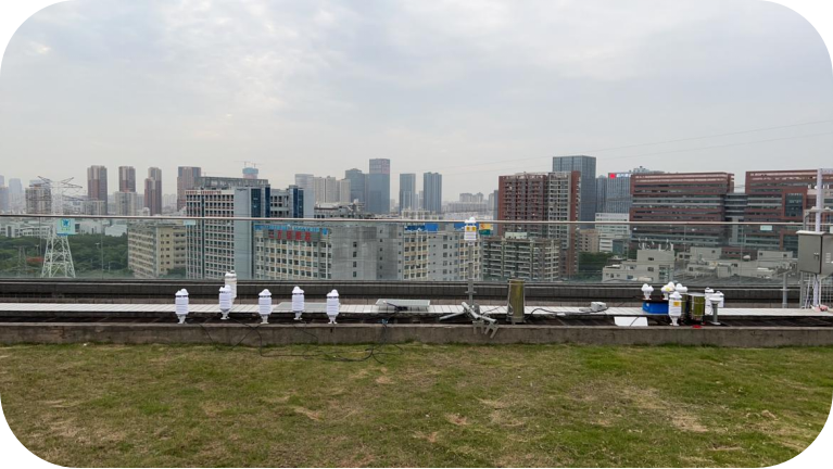
Test setup for the comparative evaluation of radar-based rainfall sensors and tipping-bucket rain gauges.
Continuous Monitoring and Data Collection
All tested devices were monitored continuously for 48 hours, during which rainfall data were collected and recorded for subsequent analysis.
After the monitoring period, the recorded data were compiled into rainfall analysis tables and measurement trend curves. These records provided a basis for comparing cumulative rainfall measurements from the radar sensors with those from the tipping-bucket rain gauges over the same observation period.
Using synchronized data collection and a common observation window helped minimize discrepancies caused by differences in recording times, making it easier to evaluate the consistency of the measurements across the tested devices.
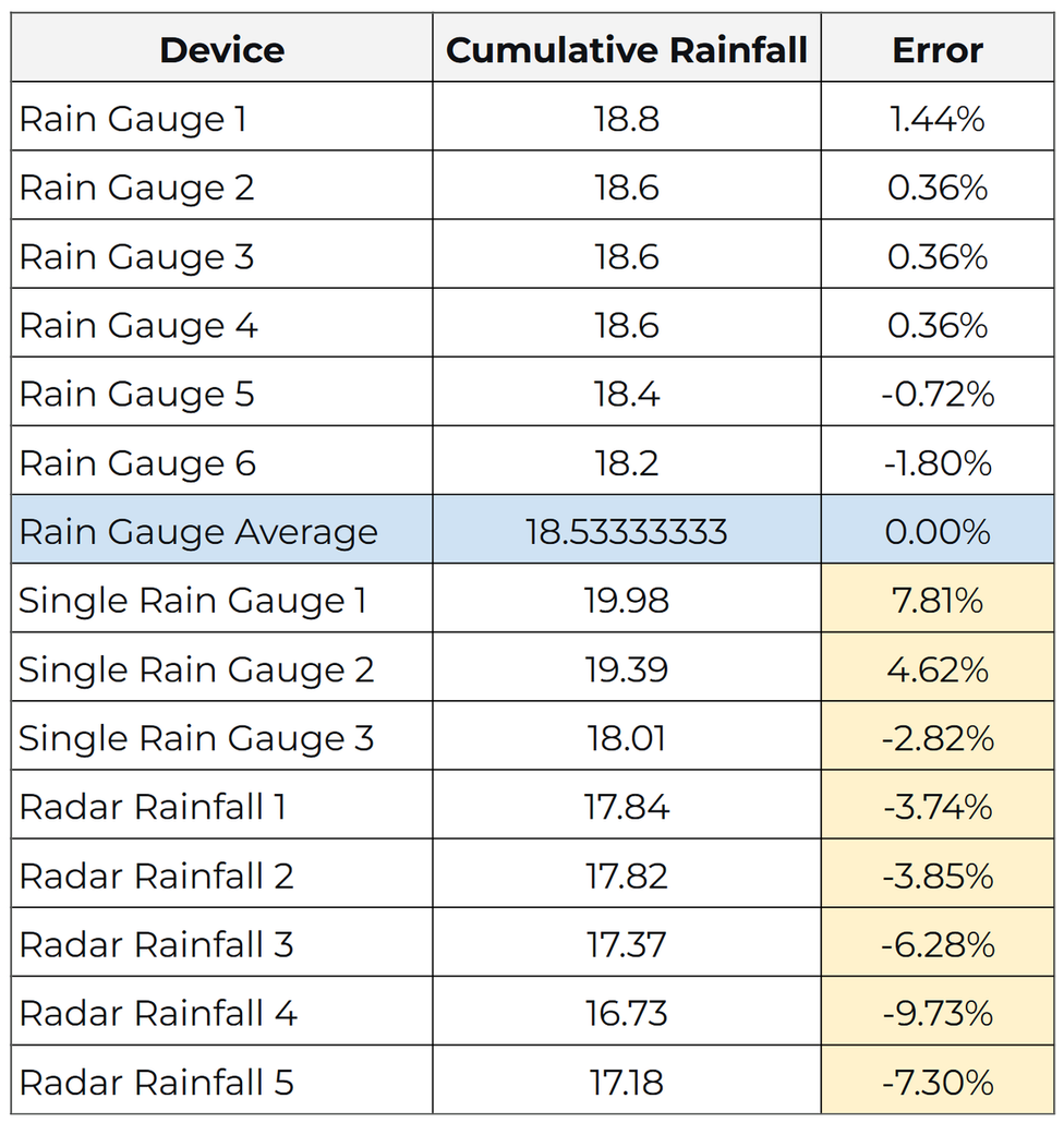
Comparison of Cumulative Rainfall Measurements Across Tested Sensors
The 48-hour comparative test demonstrated strong agreement between Doppler radar-based rainfall sensors and conventional tipping-bucket rain gauges, a widely used reference method for rainfall measurement. Under the same test conditions, the cumulative rainfall measurements from the radar sensors differed from the tipping-bucket readings by less than ±10%. This close agreement provides practical evidence of the radar sensors’ measurement precision and supports the reliability of the SenseCAP S700-C for continuous rainfall monitoring.
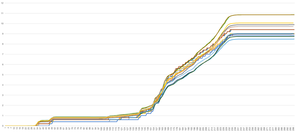
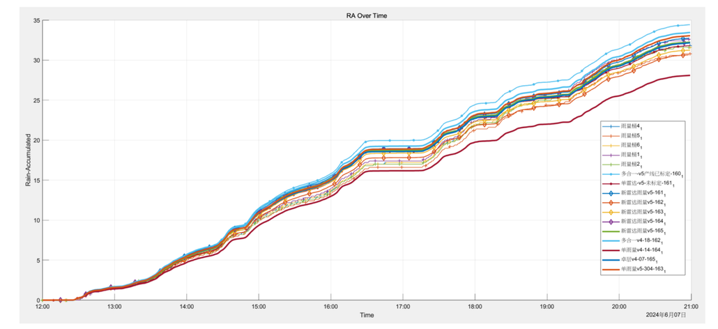
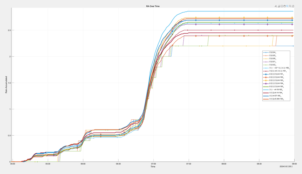
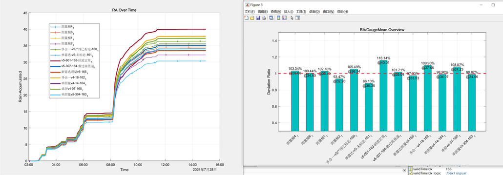
Consistency of Cumulative Rainfall Measurements Over 48 Hours
Key Findings
- High measurement consistency: The cumulative rainfall measurements from the radar sensors differed from tipping-bucket rain gauge readings by less than ±10% over the 48-hour test, demonstrating strong agreement between the two measurement methods.
- High measurement precision supported by real-world data: The close agreement with conventional tipping-bucket measurements provides experimental evidence that the radar approach can deliver reliable cumulative rainfall data under the tested conditions.
- A reliable alternative for rainfall monitoring: The results demonstrate the potential of radar-based rainfall measurement to achieve results comparable to conventional tipping-bucket gauges, supporting its use in continuous precipitation monitoring applications.
From Reliable Rainfall Data to Real-World Applications
Accurate rainfall and weather monitoring plays an important role in infrastructure management, agricultural productivity, and disaster risk reduction. From urban drainage systems and airport operations to mountain communities and offshore facilities, environmental data helps operators understand changing conditions, identify potential risks, and make better-informed decisions.
The SenseCAP S700-C combines Doppler radar-based rainfall measurement with multiple meteorological parameters, offering a way to collect localized weather data for applications that require continuous environmental monitoring. Its value extends beyond individual rainfall readings: when combined with other sensors, historical records, and application-specific models, these measurements can help build a more complete picture of local environmental conditions.
Urban Drainage and Flood Management
In coastal cities, island communities, and small urban watersheds, heavy rainfall can quickly overwhelm drainage infrastructure, particularly where catchment areas are small or drainage capacity is limited. Distributed rainfall monitoring can help municipalities understand how precipitation varies across locations, evaluate rainfall accumulation, and provide data for drainage management and flood risk assessment.
When integrated with water-level sensors, drainage monitoring systems, and hydrological models, rainfall data can help identify conditions that may contribute to urban flooding. Continuous observations can also support infrastructure planning and help authorities evaluate the effectiveness of drainage improvements, including in developing smart cities that need more localized environmental data.
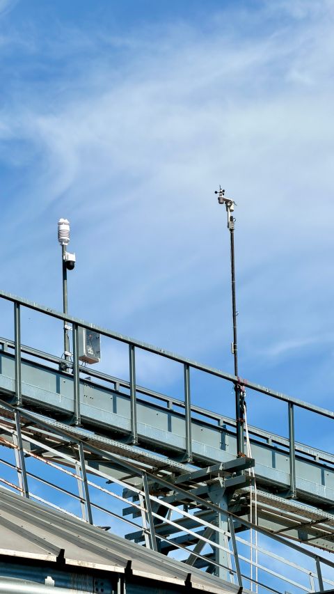
Agriculture and Irrigation Management
For farms, rainfall monitoring helps growers understand how much precipitation their fields receive and whether additional irrigation may be necessary. Tracking rainfall accumulation, precipitation intensity, and local weather trends can support irrigation scheduling, water-resource management, and the assessment of changing field conditions.
When rainfall measurements are combined with soil moisture, temperature, humidity, and solar radiation data, agricultural monitoring systems can provide a more complete view of crop growing conditions. This helps growers make irrigation decisions based on both recent precipitation and the wider environment rather than relying solely on regional weather forecasts.
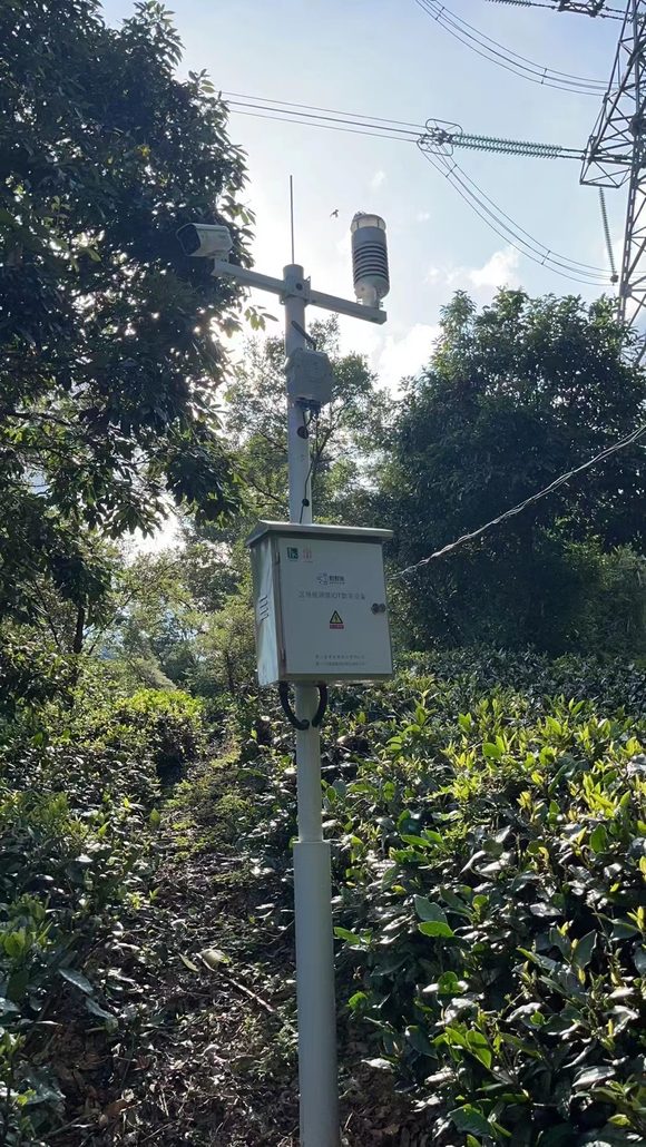
Landslide, Debris-Flow, and Flood Risk Monitoring
In mountainous areas, mining sites, open-pit mines, and villages near unstable slopes, prolonged or intense rainfall can contribute to landslides, debris flows, and flooding. Reliable local rainfall records are valuable for understanding precipitation patterns and identifying conditions that may increase these risks.
When connected with soil moisture sensors, ground movement monitoring, river or reservoir water-level sensors, and established warning models, weather monitoring stations can provide important inputs for risk assessment and early-warning systems. Rainfall measurements alone cannot predict a landslide or flood, but they can help monitoring teams identify potentially hazardous conditions and support timely investigation or response.
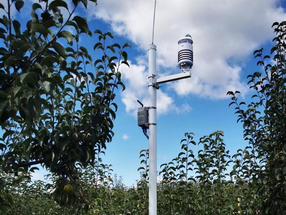
Road Weather and Frost Monitoring
On roads, bridges, and exposed transport infrastructure, falling temperatures combined with moisture can create conditions favorable for frost or ice formation. Weather stations can monitor air temperature, humidity, precipitation, and other relevant environmental parameters to help identify periods when icing may become more likely.
These measurements can support road maintenance planning, frost-risk assessment, and the deployment of dedicated road-weather sensors. However, air temperature and rainfall measurements cannot confirm whether a road surface is icy; direct surface-temperature or road-condition measurements may be needed for operational warnings.
Maritime, Ports, and Offshore Operations
Ports and offshore facilities operate in environments where changing wind, precipitation, and other weather conditions can affect safety and scheduling. In ports, localized weather observations can help operators assess conditions relevant to vessel berthing, cargo handling, and crane operations. Offshore, weather data can support operational planning for marine facilities, offshore platforms, and ocean-monitoring networks.
For offshore oil and gas operations, weather observations can contribute to decisions about work windows and personnel safety when combined with wave, current, visibility, and other marine data. Weather stations installed on ocean buoys can also provide localized observations for marine research and environmental monitoring.
For long-distance oil pipelines crossing different climate zones, distributed weather monitoring can help operators understand local environmental conditions along the route. In these applications, weather data is supplementary: pipeline integrity and leak detection require dedicated monitoring methods.
Beyond Rainfall: Toward All-Weather Precipitation Monitoring
As climate patterns become increasingly unpredictable, monitoring precipitation accurately is no longer just about measuring how much rain has fallen. Snow, hail, and mixed precipitation can also affect agriculture, transportation, water resource management, and disaster preparedness. Yet conventional rainfall measurement methods face inherent limitations when it comes to distinguishing different types of precipitation.
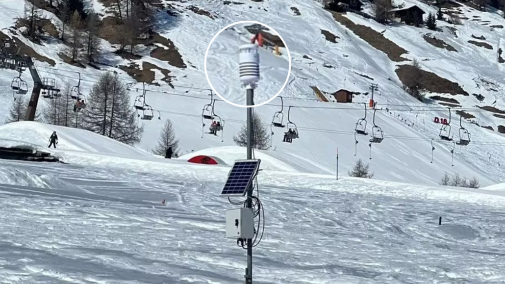
Challenge 1: Conventional Rain Gauges Cannot Reliably Distinguish Precipitation Types
Tipping-bucket rain gauges are widely used as a reference method for measuring rainfall. They work by collecting precipitation and recording the accumulated water as the bucket tips. This mechanism is effective for quantifying liquid precipitation, but it does not inherently identify whether precipitation originally fell as rain, snow, or hail.
Snow may accumulate without immediately melting into measurable water, while hail can introduce additional measurement uncertainties due to its size, impact, and melting behavior. Even when solid precipitation is converted into liquid water for measurement, the resulting accumulation alone does not reveal the original precipitation type.
This creates an important limitation for climate and environmental monitoring. Two weather events may produce similar accumulated water measurements while involving very different precipitation conditions. Without additional sensing capabilities, monitoring systems may not have enough information to distinguish these events based on rainfall data alone.
Opportunity 2: Radar Sensing Opens New Possibilities for Precipitation Classification
Unlike a conventional tipping-bucket gauge, a Doppler radar-based sensor analyzes reflected radar signals to estimate precipitation characteristics. Depending on the radar hardware, signal quality, and processing algorithms, these signals may contain information that can help distinguish different precipitation conditions.
By analyzing signal characteristics and applying carefully developed classification algorithms, radar-based sensing offers a potential path toward identifying rain, snow, and hail without relying exclusively on the collection of liquid water.
However, precipitation classification is not automatic simply because a sensor uses radar. Reliable identification requires suitable signal features, robust algorithms, and validation against observed precipitation under different environmental conditions. The feasibility and accuracy of classification also depend on the radar system’s capabilities and the complexity of the weather conditions.
What Comes Next: Advancing Precipitation Classification on the SenseCAP S700-C
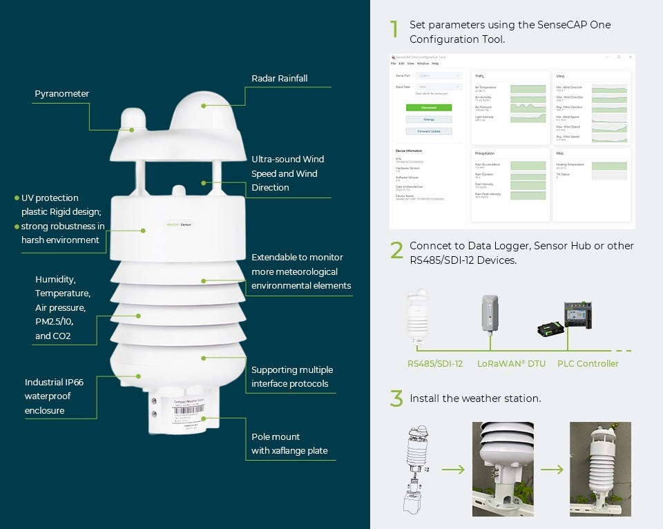
Building on its Doppler radar-based rainfall measurement technology, SenseCAP is advancing the development and implementation of algorithms intended to extend precipitation monitoring beyond rainfall.
The goal is to enable the SenseCAP S700-C to distinguish between rain, snow, and hail through future algorithm and firmware enhancements. Once the algorithms have been implemented and validated, compatible devices could potentially gain these capabilities through a firmware upgrade, reducing the need for users to replace their existing hardware.
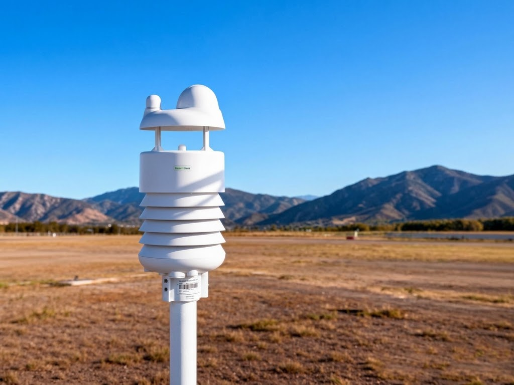
Toward More Comprehensive Climate Monitoring
The ability to distinguish precipitation types could provide more context than accumulated rainfall measurements alone. For example, identifying snowfall could help complement observations in cold-climate environments, while hail detection could contribute to monitoring severe weather events. When combined with temperature, wind, humidity, and other environmental measurements, precipitation classification could help build a more comprehensive picture of local weather conditions.
These capabilities would not replace specialized meteorological instruments or established forecasting systems. Instead, they could add another layer of information to distributed environmental monitoring networks.
As climate monitoring demands continue to evolve, advancing radar-based sensing from rainfall measurement toward precipitation classification creates new possibilities for understanding changing weather conditions. For the SenseCAP S700-C, this represents an important direction for future development: turning rainfall measurements into richer precipitation information to help address increasingly complex climate monitoring challenges.
If you have similar weather monitoring needs, contact us at [email protected]. Tell us about your project, and the Seeed team will put together a detailed solution for you.
Seeed Studio is helping lead this transition through the SenseCAP weather station portfolio. SenseCAP combines industrial-grade sensing, compact all-in-one hardware, open communication protocols, flexible data paths, and a repeatable deployment architecture.
Seeed Studio works with more than 200 partners and over 1,000 customers across 120+ countries, with SenseCAP deployments spanning greenhouse and vineyard monitoring, smart-city observation, renewable-energy sites, environmental research, and industrial facilities. This is the direction professional weather monitoring is taking, and SenseCAP is building the products and integration ecosystem needed to move it forward.
Related Articles on Radar Rainfall Measurement
Want to learn more about radar rainfall measurement, weather stations, and their applications? Explore these related articles from Seeed:
- Doppler Radar Precipitation Sensor: How Can It Measure Rain Without a Funnel?
- Radar Compact Weather Station: SenseCAP S700-C for IoT Weather Monitoring
- Agricultural Weather Station Guide: What to Measure and How to Choose
- Seeed Studio at Meteorological Technology World Expo 2026
- Best 7-in-1 Weather Stations: Features, Applications, and Selection Guide
About Author
