How to Build a Low-Power Asset Tracking System for Large-Scale Plantations
The Large Plantation Problem: Tracking Assets Across Vast, Unconnected Land
A large-scale plantation,whether palm oil, rubber, timber, tea, coffee, sugarcane, or a mixed commercial crop , is an asset-dense operation spread across a landscape that is fundamentally hostile to conventional connectivity. Consider the scale. A mid-size palm oil plantation might cover 5,000 to 20,000 hectares. A timber plantation can exceed 50,000 hectares. The following issues are encountered at the operational level:
- Where is our equipment and our people right now
- How do we track our assets and worker
- Does our staff’s work cover the entire plantation?
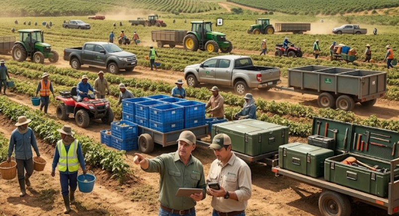
The default answer has been cellular GPS trackers. And for a truck driving on a paved highway between towns, that works. On a plantation, it is an expensive workaround that creates more problems than it solves.
Why Cellular-Only Tracking Has Limitations on Plantations
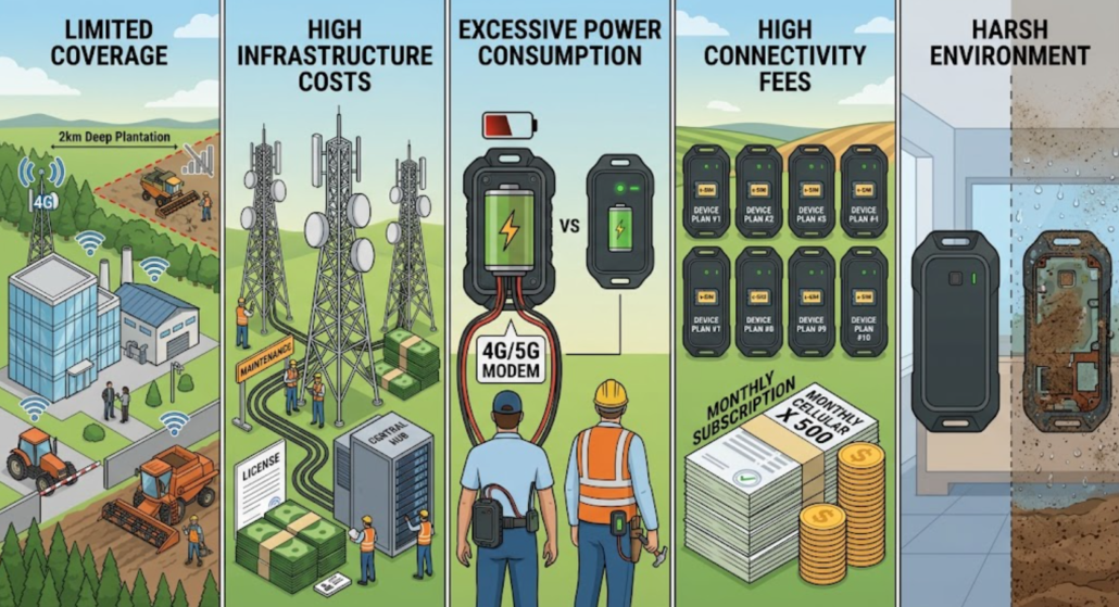
- Cellular coverage does not follow work: Plantation blocks are often located far from public cellular infrastructure. A 4G signal may exist at the main office and the mill, but vanish once a harvester drives two kilometres into a palm block or a tapper walks into a remote rubber stand. The result is a tracking system that works only where you do not need it, and goes dark exactly where equipment and people are most exposed.
- Private cellular or mesh networks are expensive to build and operate: Some large plantations invest in private LTE or proprietary radio networks. These require a grid of towers, backhaul, spectrum licensing or coordination, and ongoing carrier-grade maintenance.
- Cellular modems consume too much power for battery-powered tags: A 4G modem, even in low-power modes, draws significantly more current than a LoRa radio. For a battery-powered tag attached to a tool, a harvest bin, or worn by a worker, this means either a large and heavy battery or frequent charging and replacement.
- Per-device connectivity costs scale badly: Every cellular tracker needs a SIM and a data plan. At 500 devices, that is 500 recurring monthly subscriptions. The connectivity cost is disproportionate to the data volume.
- Environmental stress shortens device life: Plantations are hot, humid, dusty, and often chemically active . Consumer-grade cellular trackers are not built for these conditions
Why Low-Power Networking Matters in Agriculture
Agriculture has a characteristic that makes it uniquely suited to low-power wide-area networking: the data volume is tiny, but the area is enormous. This is exactly the design centre of LoRaWAN:
- Long range — a single LoRaWAN gateway can cover line-of-sight distances of several kilometres, and in open plantation terrain.
- Low power — LoRa radio transmissions are brief and low-current, enabling battery-powered tags to run for months or years on small cells.
- Low cost — no per-device SIM, no per-device data plan. A handful of gateways with a single backhaul connection serve thousands of tags.
When you combine LoRaWAN’s long-range backhaul with short-range Bluetooth beacons for zone-level positioning and GNSS for open-sky coordinates, you get a system that covers the entire plantation — including the blocks where cellular has never reached.
The principle is simple: use low-power networking for the many, and reserve high-power connectivity for the few. A plantation may need one or two cellular-connected gateways for backhaul. It does not need hundreds of cellular-connected tags.
GNSS + Bluetooth + LoRaWAN: A Three-Layer Positioning Architecture
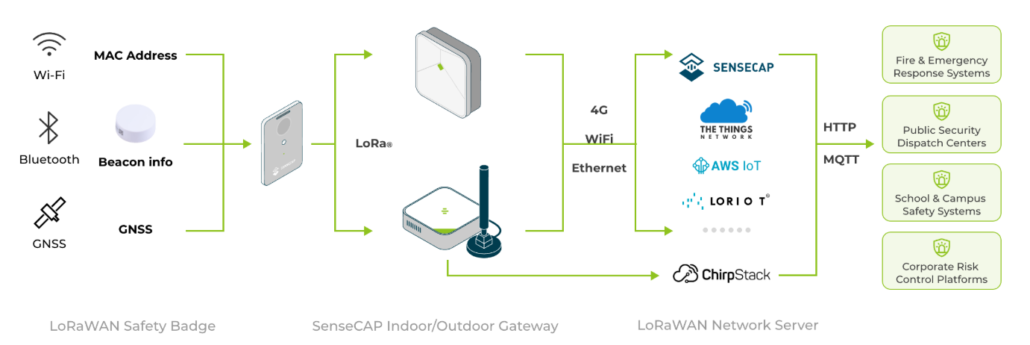
A robust plantation tracking system does not rely on a single wireless technology. It layers three complementary radios, each assigned a specific job:
| Layer | Technology | Job | Why it fits plantations |
| Positioning (open areas) | GNSS | Absolute coordinates in open fields, roads, and yards | Free, global, meter-level accuracy where sky is visible |
| Positioning (covered / dense areas) | Bluetooth Low Energy (BLE) Beacons | Zone-level or meter-level position in sheds, nurseries, mills, and dense canopy | Low cost, low power, works indoors and under canopy where GNSS is weak |
| Backhaul | LoRaWAN | Long-range, low-power uplink from every tag to the platform | Kilometre-scale range, months-to-years battery life, no per-device SIM |
| Management | Cloud / on-prem platform | Visualisation, geofencing, alerts, reporting | Where location data becomes operational decisions |
The key design insight: the tag determines its own position and ships a tiny payload over LoRaWAN. It does not need a cellular modem. In open areas it uses GNSS; in areas where GNSS is degraded or unavailable, it scans for nearby fixed BLE beacons and reports which ones it hears. The platform resolves the tag’s position from from multiple beacons for meter-level accuracy.
How the three layers work together in a plantation day
Let us follow a palm fruit bunch container from harvest to mill.
- In the field (open sky): The container has a T1000-B tag affixed to it. The tag acquires a GNSS fix and sends its coordinates over LoRaWAN to a gateway mounted on a water tower or mill roof several kilometres away.
- At the collection ramp (partial canopy / shed): A tractor drops the container at a collection point under a corrugated roof. GNSS becomes intermittent. The tag hears a BC02 beacon mounted on the ramp and reports the beacon’s MAC address over LoRaWAN. The platform knows the container is at the collection ramp.
- At the mill (indoor processing): A truck delivers the container to the mill’s receiving area. GNSS is unavailable indoors. The tag hears BC03 beacons mounted throughout the mill and reports the strongest ones. The platform resolves the container’s position to within a few metres inside the building.
- Back to the field: The empty container is loaded onto a truck and returns to the field. As it leaves the mill, GNSS reacquires, and the tag resumes coordinate reporting.
At every step, the platform shows a single, continuous location for the container — regardless of which positioning technology was used. The handoff is automatic and invisible to the operator.
Hardware Roles: T1000-B, BC02/BC03, and the LoRaWAN Gateway
T1000-B — The Mobile Asset & Personnel Tag
The T1000-B White Label Card Tracker is the mobile element of the system. Roughly the size of a credit card (85 × 55 × 6.5 mm) and IP65-rated, it can be worn as a worker badge, affixed to a toolbox or harvest bin, or mounted in a vehicle cab.
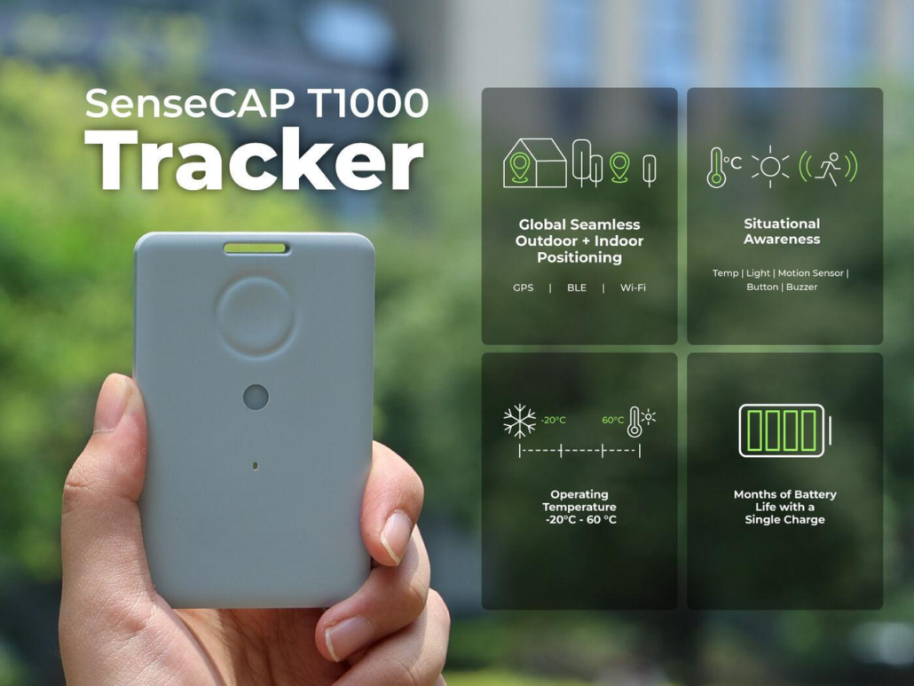
What makes it suitable for plantation tracking is that it integrates all three positioning modes in one device.
Power is a 700 mAh rechargeable lithium battery with magnetic USB charging. At a one-hour uplink interval using GNSS only, battery life reaches approximately four months; at longer intervals or in beacon-only mode, it extends further. The white-label variant means Agri-IoT integrators and solution providers can brand the device as their own, ship it under their own packaging, and present a unified solution to plantation customers without revealing the underlying hardware supplier.
BC02 — The Fixed Outdoor Bluetooth Beacon (Location Infrastructure)
The BC02 Outdoor Bluetooth Beacon is the fixed reference point of the system. Where the T1000-B moves, the BC02 stays — mounted on collection ramps, storage sheds, gate entrances, nursery structures, irrigation pump houses, and mill perimeters.
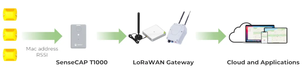
Its specifications are deliberately tuned for harsh outdoor and agricultural deployment:
- IP68 ingress protection and IK08 impact resistance — dust-tight, submersible, and resistant to the knocks, bumps, and chemical exposure common on active plantations.
- −40 °C to +85 °C operating temperature — covering both high-altitude cool-climate plantations and hot, humid tropical operations.
- 4000 mAh Li/SOCl₂ primary battery with a rated life of more than 7 years under default configuration — meaning a beacon installed at a collection point today may not need a battery change before the next major infrastructure refresh.
- BLE 5.0, iBeacon protocol, broadcasting at configurable power (−40 to +4 dBm) and interval (100 ms to 5 s), with an open-area range of up to 75 metres.
- Rugged ABS+PC enclosure, 115 × 100 × 29 mm, 169 g, with mounting flanges for screw or strap installation on posts, walls, and structures.
BC03 — The Indoor Bluetooth Beacon (for mills, sheds, and offices)
For indoor environments — processing mills, packing sheds, workshops, warehouses, and administration buildings — the BC03 Indoor Bluetooth Beacon provides the same beacon function in a compact, ceiling-mount form factor (Φ50 × 20.5 mm, ~45 g). It uses a 2400 mAh Li/SOCl₂ battery, BLE 5.0, and iBeacon protocol, with recommended installation at 2.5–3 m height and 5–10 m spacing for meter-level accuracy.
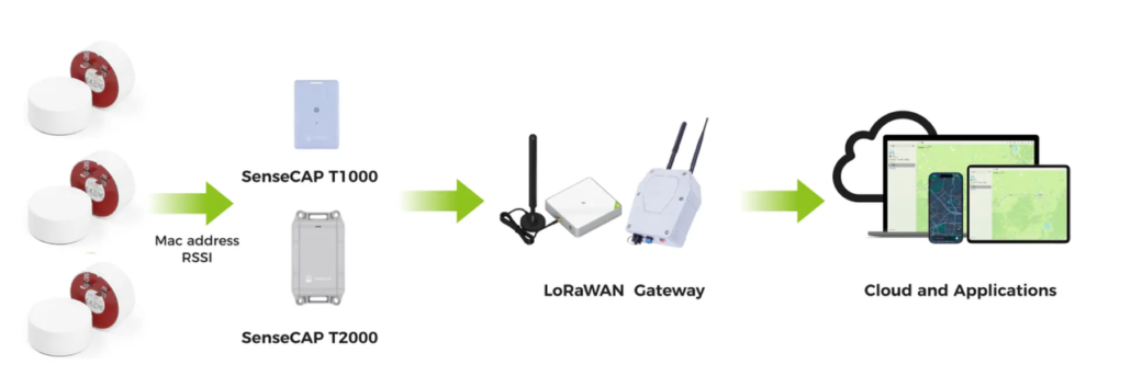
5.4 LoRaWAN Gateway — The Long-Range Data Backhaul
The gateway is the bridge between every tag’s LoRaWAN radio and the IP network. A single LoRaWAN gateway mounted on an elevated point — a mill roof, a water tower, a palm oil processing stack, an existing telecom mast, or a purpose-built tower — can cover line-of-sight ranges of several kilometres. In flat plantation terrain, two to four gateways can often cover 10,000+ hectares.
5.5 Plantation Management Platform — Data Visualisation & Management
The platform is where raw location data becomes operational value. A plantation-grade tracking platform should provide:
- Real-time location map
- Geofencing and zone alerts
- Historical tracking and replay
- Battery and device health monitoring
- API integration
The platform can be cloud-hosted or deployed on-premises, depending on the plantation’s data sovereignty and connectivity requirements. The SenseCraft Platform involves all the functions above.
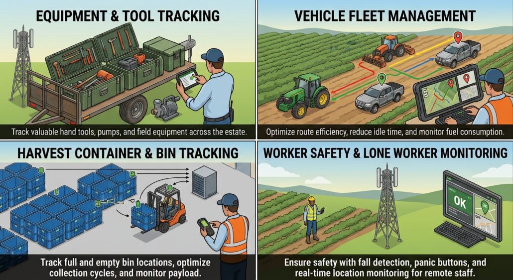
Four Plantation Use Cases
- Equipment & Tool Tracking
- Vehicle Fleet Management
- Harvest Container & Bin Tracking
- Worker Safety & Lone Worker Monitoring
Why This Architecture Wins on Total Cost
- The technical architecture matters because it translates directly into financial and operational outcomes. Compared with a cellular-only tracking approach, the LoRaWAN + BLE hybrid delivers:
- Dramatically lower connectivity cost: Instead of a cellular data plan per device, the system uses a small number of LoRaWAN gateways . The per-device connectivity cost approaches zero. For an 800-tag deployment, this alone can save tens of thousands of dollars per year.
- Lower power = smaller batteries = lower device cost: A LoRaWAN tag does not need the large battery that a cellular tracker requires. The T1000-B is a 6.5 mm-thick credit-card device with a 700 mAh battery that lasts months. Smaller, lighter devices are more comfortable for workers to wear, cheaper to manufacture, and easier to deploy on small assets and containers.
- Lower maintenance burden:Beacons with 7+ year battery life and tags with 4-month recharge cycles mean far fewer field visits for battery replacement. On a plantation, where sending a technician to a remote block costs a vehicle, a driver, and hours of travel, this is often the single largest source of total-cost savings.
- Coverage where cellular cannot reach: LoRaWAN’s long range and strong vegetation penetration mean a few gateways cover an entire plantation — including the remote blocks where building cellular coverage would be prohibitively expensive. The system works in the field, at the collection points, and (with beacon infrastructure) indoors at the mill — without a private LTE network.
- Data ownership and integration: LoRaWAN data flows into the operator’s chosen platform via open APIs. There is no lock-in to a cellular carrier’s device management platform, and location data can be integrated directly into existing plantation management, fleet, mill, and HR systems.
- Faster ROI through loss reduction: For many plantations, the fastest return on investment comes not from labour savings but from loss reduction.
The Seeed Solution: Building Blocks for Agri-IoT Providers
For agricultural system integrators and IoT solution providers, the value of this architecture is that it is modular and white-label-ready. You are not buying a closed tracking product — you are assembling a solution from interoperable building blocks that you can brand, configure, and integrate as your own.
For solution providers, this means:
- Faster time-to-deployment
- Lower R&D burden
- White-label flexibility
- Global availability
- Pilot-friendly economics
Ready to scope a tracking pilot for your plantation or your agricultural customer? Explore the T1000-B White Label Tracker and the BC02 Outdoor Bluetooth Beacon, or contact Seeed for bulk pricing, regional frequency configuration, and custom integration support.
About Author
